

14.05.2024
3 minutes of reading


Ancient geographic maps are valuable witnesses to our history, offering a unique perspective on the spatial dynamics of centuries past. Analyzing and comparing these maps with current digital data is a complex and time-consuming task but one that enables us to retrace the evolution of land occupation since the Middle Ages. Thanks to an innovative approach exploiting artificial intelligence (AI), particularly deep learning, new, easier-to-implement techniques are opening up to researchers in the field.
Cassini map analysis using an AI approach
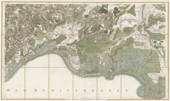
In a recent article [1], an IFPEN research team presented a method based on CNNs1 to analyze the Cassini map (example in figure 1), created in the 18th century, and compare its characteristics with current land cover data. The objective is to retrace the evolution of land occupation over time with a view to quantifying the effects of human activity on the use of space via the evolution of agricultural and pastoral activities, among others. The way land is occupied has a significant impact on its fragility; for example, land is far more susceptible to erosion when vegetation cover (particularly forests) is destroyed, thereby promoting rainwater run-off. The approach employed, known as semantic segmentation, made it possible to extract different categories of land use, such as forests, heaths, arboriculture and hydrological networks, from the Cassini map.
1 Convolutional Neural Networks
General principle of the methodology
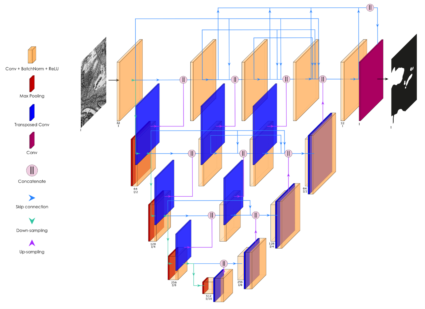
The methodology employed uses a convolutional neural network2 specifically adapted to the semantic segmentation of images (figure 2). In this approach, once a pre-defined class has been assigned to each image pixel, a new image is created in which the pixels indicate these different affiliation classes.
The convolutional neural network was trained via a data set comprising 30 small images extracted from the Cassini map, each one labeled with the different land use categories.
This semantic segmentation methodology links encoder and decoder sub-networks via dense embedded convolution blocks. The encoder plays a crucial role, capturing the characteristics of an image to varying degrees of abstraction. The decoder is then used to reconstruct the output image via a series of scaling operations and deconvolution layers.
2 U-Net++
In more detail, the main steps in the methodology used are:
1) Convolution (3 × 3) with batch standardization and ReLU3 activation extracts the characteristics.
2) Max pooling (2 × 2) reduces the input image to capture fine details and reduce the number of parameters.
3) A transposed convolution enlarges feature maps.
4) Concatenation merges the feature maps of the two sub-networks.
5) The first convolution on the input image uses 32 filters. The number of channels doubles after each convolution, while their size reduces by half after each max pooling.
3 Rectified Linear Unit : function applied to the network’s neurons and used to filter negative values
Maps that speak volumes about landscape evolution
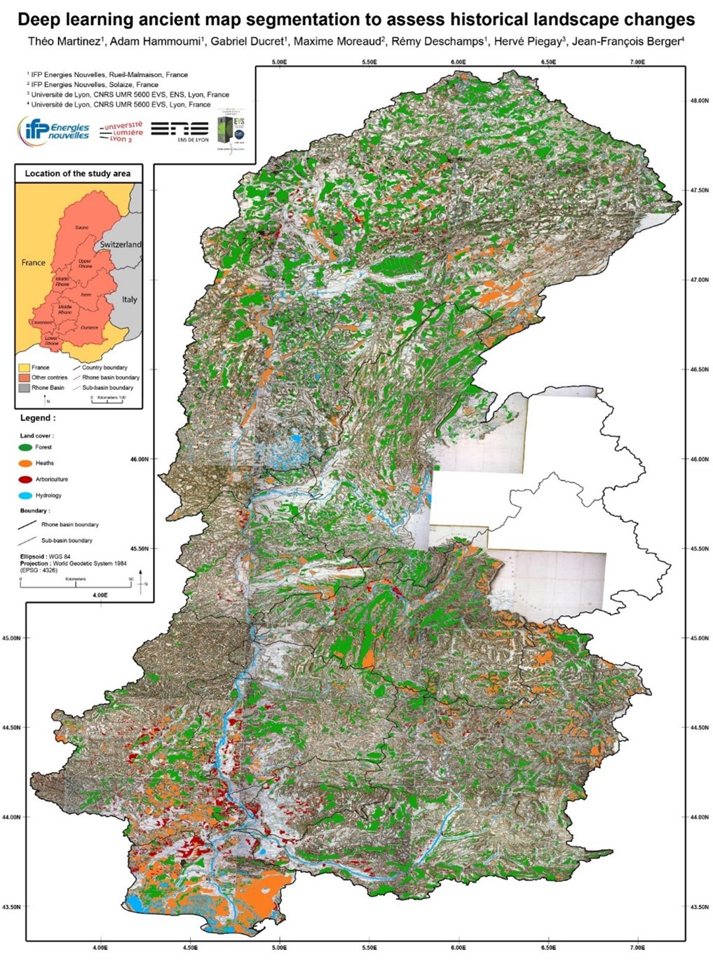
The approach adopted delivered good segmentation results with an average precision of 90% (between automatic and manual segmentations, the latter being considered to be our ground truth). Segmentation results revealed significant differences between the Cassini map and current land cover data. For example, forests currently cover a surface area more than 2.5 times greater than on the Cassini map, while the hydrological network occupies a surface area more than five times greater on the old map. For the zones considered, these results provide clues about the major changes related to climate and human activities that have taken place over the past two centuries (figure 3).
The role of AI in the study of ancient maps
It turns out that AI has a crucial role to play in analyzing ancient maps for several reasons:
- Time savings and efficiency: automated semantic segmentation significantly reduces the time required to analyze ancient maps, thereby making it possible to explore large volumes of data rapidly.
- Precision and reliability: AI techniques deliver greater precision in the identification of land use classes, leading to reliable and robust analyses.
- Enhanced historic understanding: the combination of data extracted from ancient maps thanks to AI with historic and geographic knowledge opens up opportunities for a better understanding of the concomitant evolution of landscapes and societies over the course of time.
Prospects for a better understanding of the past
This study underlines the potential of AI in the analysis of ancient geographic maps and paves the way for further such research in the field. Similar approaches could be conducted for other geographic regions and periods of history, thereby enabling a more in-depth exploration of our past.
This represents a significant and promising methodological advance insofar as it opens up new opportunities for researchers in the fields of history, geography and environmental sciences. It was used in the PhD research conducted by T. Martinez [2] to quantify sediment flows resulting from erosion in the Rhône catchment area transiting towards the delta since the Middle Ages, with a view to calibrating numerical modeling parameters and anticipating the evolution of the Rhône delta as a function of various land occupation scenarios. Finally, this study illustrates the important role that digital technologies can play in the preservation and exploitation of our mapping heritage.
References
[1] T. Martinez, A. Hammoumi, G. Ducret, M. Moreaud, R. Deschamps, H. Piegay, J.-F. Berger, (2023)
Deep learning ancient map segmentation to assess historical landscape changes,
Journal of Maps, 19:1. https://doi.org/10.1080/17445647.2023.2225071
[2] T. Martinez, Impacts des paramètres hydroclimatiques & anthropiques sur la sédimentation dans le système deltaïque du Rhône à la transition Holocène/Anthropocène (Impacts of hydroclimatic and human activity parameters on sedimentation in the Rhône delta system in the Holocene-Anthropocene transition), Université de Lyon 2, 2024
Scientific contact : gabriel.ducret@ifpen.fr
You may also be interested in

Global change, impact on landscapes and water resources
Today, the impact of climate change and human activities on the evolution of landscapes and water resources is a major challenge. Predicting it requires dedicated tools capable of evaluating, 100 years ahead, the consequences of different scenarios on watersheds and groundwater. To this end, IFPEN is developing modeling approaches targeting erosion-transport-deposition phenomena combined with surface and subsurface flows. ...

Artificial Intelligence-assisted interpretation of geological images
Over the last decade, deep learning applied to image analysis has rapidly developed in scope to cover numerous fields. However, its potential remains underexploited in geology, despite the fact that it is a discipline that relies to a large extent on visual interpretation. To contribute to the digital transformation of industries related to the underground environment, researchers at IFPEN have implemented deep learning in three “profession-specific contexts”, each involving different types of geological images.
